Asoj 2083 BSअसोज २०८३· Nepal runs on its own calendar

Eastern Nepal · viewpoint

Sandakpur

सन्दकपुर Sandakphu (Indian side)

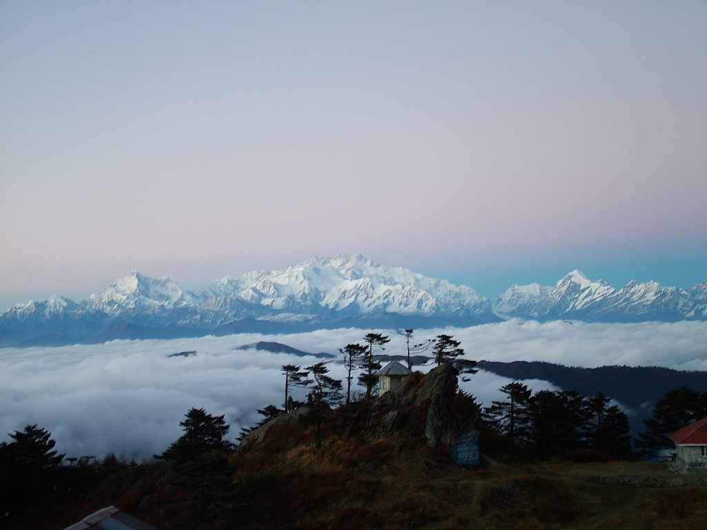
Sandakpur, called Sandakphu in India, is the 3,636 m high point of the Singalila ridge on the Nepal–India border, north of Ilam. On a clear morning you see Everest, Lhotse, Makalu and Kanchenjunga, four of the five highest mountains on earth. From Nepal it is a long jeep day or a 3–5 day walk.

  • Stay 2–4 nights
  • Best Apr · Oct – Dec
  • लेकLekh
Sandakpur
Photo: solarshakti · CC BY 2.0, Wikimedia Commons

The air at Sandakpur

Altitude3,636 m41.1% of the way to 8,849 m
BeltLekhलेक · High hills: pasture, pine, the last fields
Each breath64%of the oxygen at sea level
Water boils87.6 °Cso dal takes longer here
vs Kathmandu-14.5 °Ctypical difference by height

Oxygen, boiling point and temperature are worked out from the standard atmosphere for 3,636 m; real days vary with weather.

The Singalila ridge runs south from the Kanchenjunga massif and forms the border between Nepal and India, 3,000 to 3,600 m high for much of its length. Sandakpur is its highest point. From the top the whole Kanchenjunga range fills the northern sky, about 65 km away, and on clear mornings Everest, Lhotse and Makalu stand to the west on the horizon. Few viewpoints anywhere put four of the five highest mountains on earth in a single sweep.

Most foreigners know the Indian side, the Singalila trek from Manebhanjyang near Darjeeling, with its old Land Rovers and trekkers' huts. Far fewer come up from Nepal. The Nepali approach starts from Ilam district, through Mai Pokhari and the ridge villages of Sandakpur rural municipality, by jeep on a rough road or on foot over several days. It is quieter, more rural and closer to village life than the Indian route.

The summit area straddles the border, and its lodges and huts are on the Indian side. On the Nepal side are smaller settlements and homestays, run by farming and herding families. We plan the trip so you are on the ridge for sunrise, with a night as close to the top as current rules and roads allow, and a spare morning in case cloud hides the view the first time.

Why go

Four eight-thousanders at sunrise

On clear mornings, Everest (8,849 m), Lhotse, Makalu and Kanchenjunga (8,586 m) are visible from the top, four of the five highest mountains in the world. October to December gives the best chance of a clean view.

The full Kanchenjunga range

Kanchenjunga and its neighbours stretch across the northern horizon about 65 km away, with Jannu (Kumbhakarna) to its west. The long profile of the range is what most people come for, and it fills a wide-angle frame.

Rhododendron forest in April

The ridge forests are full of rhododendron, magnolia and bamboo. In April the gurans bloom red, pink and white along the trail, and the mornings are often clear enough for views before cloud rises from the valleys.

The Nepal-side approach

Few foreigners come up from Ilam. The Nepal-side route passes Mai Pokhari, farm villages and ridge forest, with homestays rather than trekkers' lodges, and very little traffic on the trail even in October.

Red panda country

The bamboo and rhododendron forests along the Singalila ridge are home to red pandas. Sightings are rare and need luck and patience, but the habitat is easy to see from the trail, especially in the quiet early hours.

१The story of Sandakpur

The ridge between two countries

The Singalila ridge lies between Limbuwan, the old Limbu homeland to the west, and Sikkim to the east. Herders have long brought cattle and yaks up to its high pastures in summer, and footpaths follow the crest rather than the steep river valleys below. The border between Nepal and Sikkim, and later India, was drawn along the watershed, which is why the frontier today follows the ridge almost exactly, marked by small pillars along the trail.

In the 20th century Sandakphu became famous from the Darjeeling side, where colonial-era walkers and later Indian trekkers came for the view of Kanchenjunga. The Indian side protected its forests as Singalila National Park, and a jeep road along the ridge brought a steady stream of visitors. On the Nepal side, the ridge stayed a farming and herding frontier, reached by footpaths from Ilam and visited mostly by local people, traders and pilgrims to Mai Pokhari below.

That is slowly changing. Since 2017 the ridge villages have formed Sandakpur rural municipality, named after the peak, and the municipality promotes the Nepal-side route with jeep tracks, homestays and viewpoints. Visitor numbers on the Nepal side remain small, and the walk through rhododendron and bamboo forest still feels like a farm trail more than a tourist route. Families who once lived only from cardamom, potatoes and cattle now host guests as well.

२The legend
As it is told · सन्दकपुर

People who live in the shadow of Kanchenjunga say its name means the five treasures of the high snow. In a belief held by the Lhopo of Sikkim and shared in stories on both sides of the ridge, the five summits hide treasures such as salt, gold and turquoise, sacred scriptures, armour, grain and medicine, which will be revealed to the devout when the world is in danger. From Sandakpur you look straight at those five summits.

३The people

Who lives here

The settlements along the Nepal side of the ridge are small and mixed: Sherpa and other families of Tibetan descent who herd yaks and run lodges higher up, and Limbu, Rai, Gurung, Tamang and Chhetri farming households lower down. Many grow cardamom, potatoes and vegetables, and keep cattle. Nepali is the common language. Families on both sides of the border are often related and cross freely.

Local name: Sandakphu (Indian side)

४Words you will hear
Nepali
गुराँस
gurans

Rhododendron, Nepal's national flower, which turns the ridge red in April

Nepali
हिमाल
himal

Snow mountain or range

Tibetan
ལྷ་རྒྱལ་ལོ
lha gyalo

Victory to the gods, said on high passes and summits

Every word on this site

५What to eat

Chhurpi

Hard, smoked cheese made from yak or cow milk, cut into small cubes and chewed for an hour or more. Herders and lodge owners on the ridge make and sell it. Buy a string from a lodge or in Ilam bazaar for the walk; it lasts for weeks.

६Few people know

Things most guides leave out

Sandakphu, at 3,636 m, is the highest point of the Singalila ridge and also the highest point of the Indian state of West Bengal, while sitting on the border with Nepal.

Wikipedia: Sandakphu

Sandakpur rural municipality in Ilam district was created on 10 March 2017 in Nepal's restructuring of local government, and it includes the Mai Pokhari Ramsar wetland as well as the Sandakpur peak area.

Wikipedia: Sandakpur Rural Municipality

The Singalila ridge, 3,000–3,500 m high south of Kanchenjunga, is the line that separates Sikkim in India from Nepal, which is why the border runs along the trail at Sandakpur.

Wikipedia: Kangchenjunga

Untold Nepal, region by region

Getting there

How to reach Sandakpur

Road

From Ilam bazaar, jeep tracks climb north through Mai Pokhari and the ridge villages toward the Sandakpur area, a long and rough day of roughly 6–8 hours. Sections are unpaved and can close in the monsoon. Check current status before you travel.

On foot

A walking route from the Ilam side takes 3–5 days up and down, staying in village homestays, with the last day on the forested ridge. We can combine jeep and walking to fit your time.

Air

The nearest airport is Bhadrapur in Jhapa, about 45–50 minutes from Kathmandu. From there it is 3–4 hours to Ilam before the climb to the ridge.

Where to stay

On the Nepal side, stays are village homestays and small family lodges along the ridge approach, with shared toilets, thick blankets and dal bhat cooked on a wood stove. The established lodges and huts at the summit itself sit on the Indian side of the border. Before and after the ridge, Ilam bazaar has simple hotels and guesthouses. We confirm current homestays and border arrangements before each trip.

Local tips

  • Aim for October to December for the clearest views; spring brings flowers but more haze and afternoon cloud.
  • At 3,636 m nights fall below freezing for much of the year, so bring a warm sleeping bag and down jacket.
  • Ascend gradually and drink plenty of water; mild altitude headaches are common on the first night above 3,000 m.
  • Foreign nationals other than Indians should not cross onto the Indian side of the ridge without the correct Indian visa and permits.
  • Carry cash in Nepali rupees and a power bank; there are no ATMs and electricity on the ridge can be limited.

On the map

Sandakpur and what is near it

Map of Sandakpur, Ilam, Kanyam, PathibharaIndiaChinaBhutanBangladeshNepalKoshiSandakpur1SandakpurIlam2IlamKanyam3KanyamPathibhara4Pathibhara50 kmN
  1. 1Sandakpur
  2. 2Ilam
  3. 3Kanyam
  4. 4Pathibhara
Drawn by Book Nepal Trip from Natural Earth outlines (public domain). International borders as depicted by Nepal. Rivers: Karnali, Gandaki and Koshi systems. Not for navigation.

Questions

Sandakpur: what travellers ask

Is Sandakpur in Nepal or India?

Both. Sandakpur, called Sandakphu in India, sits on the border along the Singalila ridge. The summit area and its lodges are on the Indian side, in West Bengal, while the slopes and villages to the west are in Sandakpur rural municipality, Ilam district, Nepal.

Which mountains can you see from Sandakpur?

On a clear day: Kanchenjunga (8,586 m) and its range to the north, and Everest, Lhotse and Makalu to the west. That is four of the five highest mountains in the world. Smaller peaks such as Jannu (Kumbhakarna) are also visible near Kanchenjunga.

How do I reach Sandakpur from Kathmandu?

Fly to Bhadrapur (about 45–50 minutes), drive 3–4 hours to Ilam, then either take a long jeep day north to the ridge or walk 3–5 days from the Ilam side. Allow at least 5–6 days from Kathmandu and back. Check current status of roads before you travel.

What is the best time to visit Sandakpur?

October to December gives the clearest mountain views. March and April bring rhododendron flowers with more haze and afternoon cloud. January and February are clear but very cold, with possible snow. June to September is monsoon, with cloud, rain and leeches.

How cold is Sandakpur?

Nights at 3,636 m drop below freezing for much of the year and well below in December to February, with possible snow. Days can be pleasant in sun. Bring a down jacket, warm sleeping bag, hat and gloves in all seasons except high summer.

Can foreigners cross to the Indian side at Sandakpur?

Nepali and Indian citizens cross the ridge freely. Other nationals need a valid Indian visa and the permits required for Singalila National Park, and there is no formal immigration post on the ridge. We plan Nepal-side routes for foreign travellers. Check current status before you travel.

Is the Nepal-side Sandakpur trek crowded?

No. Most trekkers use the Indian route from Manebhanjyang. On the Nepal side from Ilam you mostly meet farmers, herders and the occasional group of Nepali visitors, especially in autumn. Holidays such as Dashain bring more domestic visitors, but the trail is still quiet by Nepal standards.

Do I need a guide for Sandakpur?

We strongly recommend a licensed local guide. The Nepal-side paths are not well signed, homestays need arranging, the border runs along the ridge, and weather changes fast. A guide also makes the village stays far richer, translating and explaining what you see.

How many days do I need for Sandakpur?

From Ilam: two days by jeep with one night near the top, or 3–5 days on foot. Add a spare night for weather. Including travel from Kathmandu, plan 6–8 days for a relaxed trip with time in Ilam's tea gardens.

Plan with a local planner

Tell us your height, we will find the trail

Easy hills or a 5,000 m pass, a week or a month: three short questions and a planner sends a first plan, with the sleeping height of every night and an itemised price.

  1. १Tell us where, when and how high you want to go
  2. २Get a first plan and an itemised price within one working day
  3. ३Change anything until it fits. Pay a deposit only when you book
Plan my Nepal trip