Asoj 2083 BSअसोज २०८३· Nepal runs on its own calendar

Eastern Nepal · trek stop

Ghunsa

घुन्सा

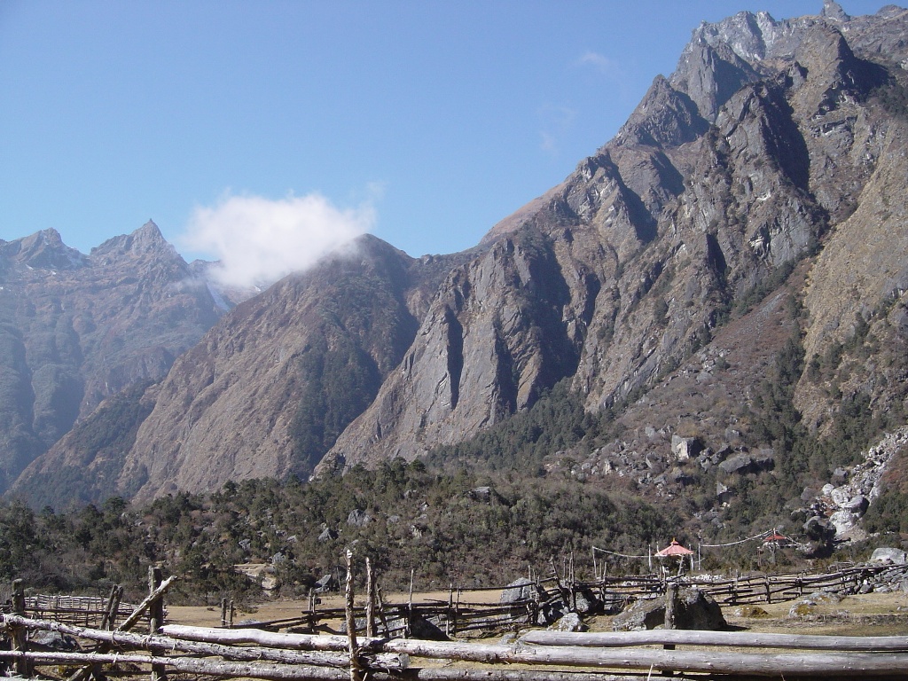
Ghunsa is a Buddhist village at 3,475 m in the upper Ghunsa valley of Taplejung, inside the Kanchenjunga Conservation Area. It is the main village and checkpoint on the trek to Kanchenjunga's north base camp at Pang Pema, and the usual place to rest and acclimatise for a day before going higher.

  • Stay 2 nights
  • Best Apr – May · Oct – Nov
  • लेकLekh
Ghunsa
Photo: Nirmaljoshi · CC BY-SA 4.0, Wikimedia Commons

The air at Ghunsa

Altitude3,475 m39.3% of the way to 8,849 m
BeltLekhलेक · High hills: pasture, pine, the last fields
Each breath65%of the oxygen at sea level
Water boils88.2 °Cso dal takes longer here
vs Kathmandu-13.5 °Ctypical difference by height

Oxygen, boiling point and temperature are worked out from the standard atmosphere for 3,475 m; real days vary with weather.

After days of walking up the Tamor and Ghunsa valleys through forest and Hindu and Limbu farming villages, the trail reaches Ghunsa and the culture changes. Houses are built of stone and timber, prayer flags fly from poles, and a gompa sits above the village. The people here are Buddhists of Tibetan descent, and many speak a Tibetan dialect at home. Mani walls line the trail, and the smell of juniper smoke drifts from the kitchens in the evening.

Ghunsa is the largest settlement in the upper valley and the place where trekkers stop for a rest day before climbing to Kambachen, Lhonak and Pang Pema. It has lodges, a checkpoint for the Kanchenjunga Conservation Area, small shops and the last reliable supplies before the high country. Guides and porters use the stop to rest, dry clothes and buy food, and the village has the feel of a busy waypoint during the trekking seasons.

It is a good place to slow down. Use the rest day for a hike up the valley side, a visit to the gompa, and time in the kitchen of your lodge, where the family will make you salt butter tea if you ask. Walk the lanes in the late afternoon when the yaks come in, and go to bed early: the days that follow climb well above 4,000 m, and a rested body copes far better with the thin air.

Why go

The village gompa

The Buddhist temple above the village holds statues, murals and the butter lamps of daily worship. Visit with your guide in the early morning, walk clockwise, leave a small donation, and ask before taking photographs inside.

Acclimatisation hike above the village

On the rest day, a 3–4 hour hike up the slopes above Ghunsa, gaining 300–500 m, helps your body adjust before Kambachen and Lhonak. Views open up the valley toward the high peaks.

Stone and timber houses

Ghunsa's houses are built of stone and wood, with prayer flags on tall poles and stacks of firewood under the eaves. Walk the lanes in the evening when the yaks come in.

Gateway to Pang Pema

From Ghunsa the trail climbs to Kambachen (about 4,050 m), Lhonak (about 4,780 m) and Pang Pema (about 5,140 m), under the north face of Kanchenjunga. Ghunsa is your last proper village.

A conservation story

Ghunsa is inside the Kanchenjunga Conservation Area, managed by a local council since 2006. Snow leopards, blue sheep and red pandas live in the area. Your permit fees help fund local conservation.

१The story of Ghunsa

A Tibetan village at the head of the Ghunsa valley

The families of Ghunsa trace their origins to Tibet, and the village has long lived from yak herding, trade over the high passes and farming of potatoes and barley in the short summer. Like other Himalayan Buddhist villages, they move between settlements at different heights through the year, following pasture and weather. Their religious life centres on the village gompa, mani walls and the festivals of the Tibetan calendar, and their houses keep a shrine room or altar with butter lamps.

In 1997 the government declared the Kanchenjunga Conservation Area, 2,035 km² of Taplejung's high country bordering Tibet and Sikkim. In September 2006 management of the area was handed to a council of local people, one of the first such handovers in Nepal. On 23 September 2006, a chartered helicopter on a flight linked to the handover ceremony at Ghunsa crashed in the Taplejung mountains, killing all 24 people on board, including leading Nepali conservationists, government officials and WWF staff.

The loss was felt across Nepal, and the village is still linked with it in the national memory. Since then the local council has continued to manage the conservation area, using permit fees for community projects, trail work and conservation. Ghunsa today is busier than it was, with more lodges and trekkers each autumn and spring, and roads creeping up the lower valleys. But the families still keep yaks, plant potatoes and run their homes much as before, and the gompa remains the heart of village life.
३The people

Who lives here

Ghunsa's people are Buddhists of Tibetan descent, often grouped with the Sherpa or with the Tibetan-speaking communities of the northern border, though they have their own local identity. They speak a Tibetan dialect and Nepali, and some speak English from years of lodge work. Families herd yaks, grow potatoes and barley, trade, run lodges and work as guides and porters on the Kanchenjunga trek.

४Words you will hear
Tibetan
དགོན་པ
gompa

Buddhist monastery or temple

Tibetan
མ་ཎི
mani

Prayer stones carved with om mani padme hum, passed on the left

Nepali
खर्क
kharka

High summer pasture for yaks and cattle

Every word on this site

५What to eat

Po cha (butter tea)

Salted tea churned with butter, drunk all day in Tibetan Buddhist homes. In Ghunsa, lodge families make it in a tall wooden churn or a flask. It tastes more like a thin soup than tea and helps at altitude. Ask for it in the lodge kitchen.

६Few people know

Things most guides leave out

The Kanchenjunga Conservation Area was established in 1997 and covers 2,035 km² of Taplejung district. It adjoins Qomolangma National Nature Preserve in Tibet and Khangchendzonga National Park in Sikkim.

Wikipedia: Kanchenjunga Conservation Area

On 23 September 2006 a chartered helicopter flying between Phungling and Ghunsa crashed, killing all 24 people aboard, including a WWF team, during the creation of the locally managed Kanchenjunga Conservation Area.

Wikipedia: 2006 Shree Air Mil Mi-8 crash

Ghunsa lies at about 3,475 m in Taplejung and is the main village and checkpoint on the trekking route to Kanchenjunga's northern base camp at Pang Pema.

Wikipedia: Ghunsa

Untold Nepal, region by region

Getting there

How to reach Ghunsa

On foot

From Taplejung (Phungling), the trek up the Tamor and Ghunsa valleys to Ghunsa takes about 5–7 days, depending on how far roads and jeeps can take you. New roads have pushed up the valleys in recent years and shortened the walk. Check current status before you travel.

Road

Reach Taplejung via Bhadrapur or Biratnagar and the Mechi Highway north through Ilam and Panchthar, a long day of driving. From Taplejung, jeeps go up the Tamor valley as far as the road is open.

Where to stay

Ghunsa has several family-run teahouses with twin rooms, shared toilets, a dining room heated by a stove and a menu of dal bhat, noodles, potatoes and Tibetan bread. Rooms are basic and cold at night, so bring a good sleeping bag. Hot showers and phone charging are usually available for a fee. Ghunsa is the most comfortable stop between Taplejung and Pang Pema. Lodges above it at Kambachen and Lhonak are simpler still.

Local tips

  • Take a full rest day in Ghunsa before going higher; it is the single most useful thing you can do for acclimatisation.
  • Buy any last supplies here; shops above Ghunsa are few and expensive.
  • Walk clockwise around gompas, chortens and mani walls, and do not touch religious objects without asking.
  • Carry enough cash in Nepali rupees for the whole trek; there are no ATMs in the Kanchenjunga region.
  • Nights at 3,475 m are below freezing from October to April; bring a sleeping bag rated to about minus 15 °C.

On the map

Ghunsa and what is near it

Map of Ghunsa, Pang Pema, PathibharaIndiaChinaBhutanNepalKoshiGhunsa1GhunsaPang Pema2Pang PemaPathibhara3Pathibhara50 kmN
  1. 1Ghunsa
  2. 2Pang Pema
  3. 3Pathibhara
Drawn by Book Nepal Trip from Natural Earth outlines (public domain). International borders as depicted by Nepal. Rivers: Karnali, Gandaki and Koshi systems. Not for navigation.

Questions

Ghunsa: what travellers ask

Where is Ghunsa?

Ghunsa is a village at about 3,475 m in the upper Ghunsa valley, Taplejung district, far north-eastern Nepal, inside the Kanchenjunga Conservation Area. It lies on the trek to Pang Pema, the north base camp of Kanchenjunga.

How many days does it take to reach Ghunsa?

From Taplejung it usually takes about 5–7 days of trekking, depending on how far jeeps can drive up the valley. Add 1–2 days from Kathmandu to Taplejung by flight and road. Roads are changing quickly here; check current status before you travel.

What permits do I need for Ghunsa?

A Kanchenjunga Conservation Area permit and a Kanchenjunga restricted area permit. As we understand it, the restricted permit needs at least two trekkers, booking through a registered agency and a licensed guide. Since April 2023 a licensed guide is required for foreign trekkers anyway. Check current status before you travel.

Are there lodges in Ghunsa?

Yes. Ghunsa has several family-run teahouses with simple twin rooms, shared toilets, stove-heated dining rooms and hot meals. It is the best equipped village on the north side of the Kanchenjunga trek, with small shops and paid hot showers.

Is there mobile signal or wifi in Ghunsa?

Mobile coverage in the Kanchenjunga region is patchy and wifi, where offered, is slow and paid. Do not rely on either for bookings or emergencies. Many trekking groups, including ours, carry a satellite messenger so they can call for help if needed.

What is the weather like in Ghunsa?

In October and November days are usually clear and cool, with nights well below freezing. April and May are milder with more afternoon cloud. December to February is very cold with snow, and June to September is wet with cloud and leeches lower down.

Do I need a rest day in Ghunsa?

Yes. Most safe itineraries spend two nights in Ghunsa, with a short hike higher on the rest day, before continuing to Kambachen and Lhonak. Skipping it raises the risk of altitude sickness and makes the climb to Pang Pema much harder.

Can I go from Ghunsa to the south side of Kanchenjunga?

Yes. The full Kanchenjunga circuit links the north and south base camps by crossing high passes between Ghunsa and the Yalung side. It is a longer, harder trek that needs extra days and good weather. Ask us for the route and current conditions.

Who lives in Ghunsa?

Buddhist families of Tibetan descent who speak a Tibetan dialect and Nepali. They herd yaks, grow potatoes and barley, trade, run lodges and work on treks. The village has a gompa, mani walls and prayer flags.

Plan with a local planner

Tell us your height, we will find the trail

Easy hills or a 5,000 m pass, a week or a month: three short questions and a planner sends a first plan, with the sleeping height of every night and an itemised price.

  1. १Tell us where, when and how high you want to go
  2. २Get a first plan and an itemised price within one working day
  3. ३Change anything until it fits. Pay a deposit only when you book
Plan my Nepal trip