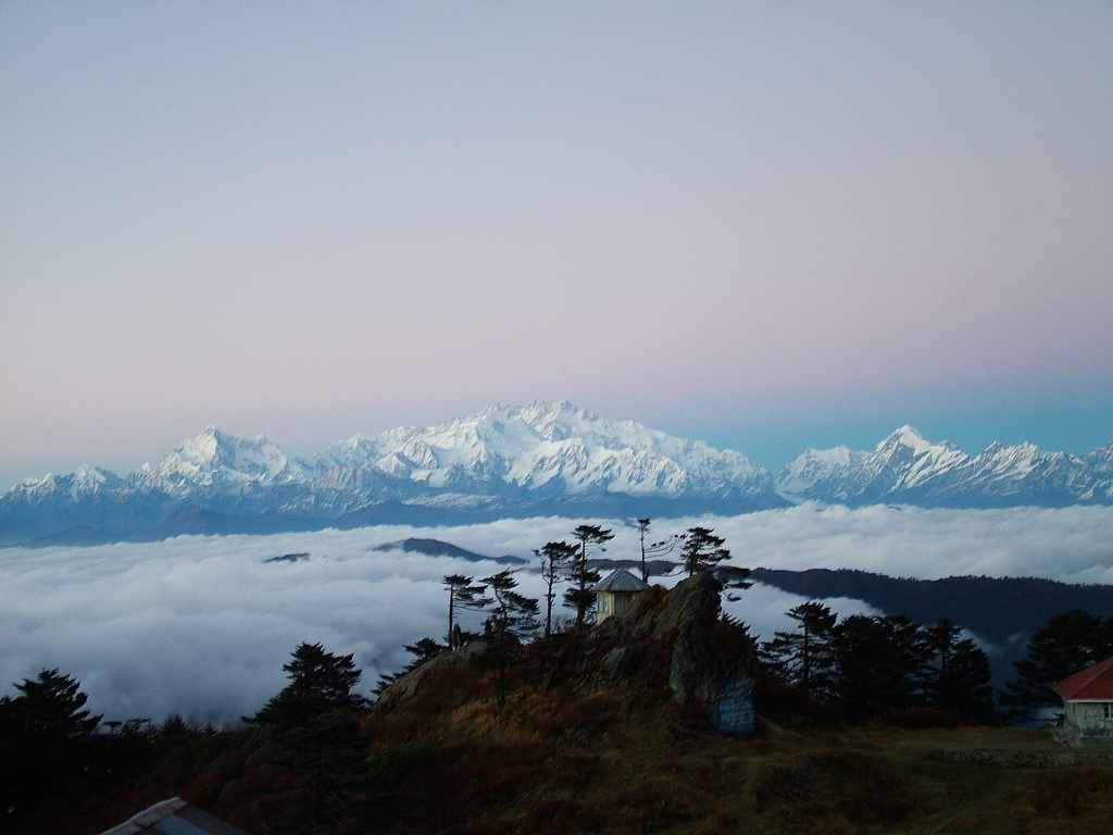
Four giants on one horizon
There are fourteen mountains on earth higher than 8,000 m, all in the Himalaya and Karakoram, and eight of them stand in Nepal. Four rise in a line along the eastern half of the country, between the Khumbu and the Sikkim border: Everest at 8,849 m, Kanchenjunga at 8,586 m, Lhotse at 8,516 m and Makalu at 8,485 m. They are the first, third, fourth and fifth highest mountains in the world. Only K2, in the Karakoram, breaks the sequence.
From the right place in eastern Nepal you can see all four at once. That place is Sandakpur, on the Singalila ridge above Ilam, where at sunrise on a clear autumn morning Kanchenjunga fills the north and Everest, Lhotse and Makalu stand together on the western horizon. Elsewhere in the east you can walk to the foot of two of them, Kanchenjunga and Makalu, on some of the wildest treks in Nepal.
This guide tells a little of each mountain's story and suggests where to stand to see it.
| Mountain | Height | World rank | First ascent | Best view in the east |
|---|---|---|---|---|
| Everest | 8,849 m | 1 | 29 May 1953 | Sandakpur, ridge above Makalu Base Camp |
| Kanchenjunga | 8,586 m | 3 | 25 May 1955 | Pang Pema, Oktang, Sandakpur, Pathibhara |
| Lhotse | 8,516 m | 4 | 18 May 1956 | Sandakpur, ridge above Makalu Base Camp |
| Makalu | 8,485 m | 5 | 15 May 1955 | Makalu Base Camp, Shipton La, Sandakpur |
Kanchenjunga, the five treasures
Kanchenjunga is the mountain of the east. Its name is usually explained as the five treasures of the high snow, after its five summits, and in Sikkim, across the border, it is honoured as a guardian deity; the Sikkimese festival of Pang Lhabsol is held in its honour. For the Limbu people of Taplejung, the mountain and its glaciers are part of a sacred landscape that also includes Pathibhara, which they call Mukkumlung.
Until the survey calculations of the 1850s, Kanchenjunga was thought to be the highest mountain in the world. The British expedition that made the first ascent on 25 May 1955 came up the Yalung glacier on the south-west side, and the summit pair, Joe Brown and George Band, stopped just short of the very top, honouring a promise made to the ruler of Sikkim that the summit itself would be left untouched. Many climbers since have kept the same custom.
In the east you can see Kanchenjunga from almost every high ridge. The great close views are from Pang Pema, the north base camp at 5,140 m, where the north face rises more than 3,000 m above you, and from Oktang above the Yalung glacier, where the south face fills the head of the valley. From Sandakpur and Pathibhara it is the dominant mountain on the northern skyline.
Makalu, the dark pyramid
Makalu stands about 19 km south-east of Everest, a four-sided pyramid of granite with sharp ridges and steep faces, isolated enough that it looks larger than its height. Its name is often linked to Maha Kala, a fierce form of Shiva, though the origin is not certain. It was first climbed on 15 May 1955 by the French climbers Lionel Terray and Jean Couzy, in an expedition led by Jean Franco, and the rest of the team reached the top on the following days.
The Makalu Base Camp trek takes you right below its south face, at 4,870 m at the head of the Barun valley. The mountain rises about 3,600 m above the huts. From Shipton La on the way in you see it ahead, and from Sandakpur it is the easternmost of the three peaks on the western horizon, its shape unmistakable.
A planner can turn what you are reading into days, nights and a price.
Everest and Lhotse from the east
Everest, Sagarmatha in Nepali and Chomolungma in Tibetan, needs little introduction. It was identified as the highest mountain on earth by the Great Trigonometrical Survey of India in the 1850s, named after the former Surveyor General Sir George Everest in 1865, and first climbed on 29 May 1953 by Edmund Hillary and Tenzing Norgay. Its height of 8,849 m was agreed by Nepal and China after new surveys announced in 2020.
Lhotse, at 8,516 m, is joined to Everest by the South Col, and its name means south peak in Tibetan. It was first climbed on 18 May 1956 by the Swiss climbers Ernst Reiss and Fritz Luchsinger. From most angles it hides behind or merges with Everest, but from the east the two stand side by side.
Most visitors see these peaks from the Khumbu. The eastern view is rarer and, we think, more striking. From the ridge above Makalu Base Camp, on a clear morning, Everest and Lhotse appear to the west at close range, from a side few trekkers ever see. From Sandakpur, about 140 km from Everest, they stand small and sharp on the horizon beside Makalu.
Where to stand
Each viewpoint gives a different picture. Choose by how much time you have, how high you want to go and whether you want the panorama or the close-up.
If you have only a few days, Sandakpur gives the most for the least effort: four 8,000 m peaks from a ridge you can reach by jeep. If you have three weeks and strong legs, nothing compares with standing under Kanchenjunga's north face at Pang Pema or below Makalu at the head of the Barun, where the mountains are no longer a view but the whole sky.
- Sandakpur, 3,636 m: all four peaks at sunrise; reach it by jeep from Ilam in a day, with a night on the way
- Pathibhara Devi, 3,794 m: Kanchenjunga and Jannu close to the north-east, after a 3–4 hour climb from the road head
- Pang Pema, 5,140 m: the north face of Kanchenjunga, at the end of the Kanchenjunga North Base Camp trek
- Oktang, about 4,730 m: the south face of Kanchenjunga above the Yalung glacier
- Makalu Base Camp, 4,870 m: Makalu's south face, with Everest and Lhotse from the ridge above
- The flight from Kathmandu to Bhadrapur: sit on the left heading east for a long line of peaks from Everest to Kanchenjunga on a clear morning
Their neighbours
The four giants have neighbours that are almost as impressive. Jannu, 7,710 m, called Kumbhakarna in Nepali after a giant in the Ramayana, towers over the Kambachen meadow on the way to Pang Pema and is one of the most striking mountains in Nepal. Chamlang, 7,319 m, and Baruntse, 7,129 m, frame the Barun valley near Makalu Base Camp. Kabru and Rathong stand at the head of the Yalung glacier beside Kanchenjunga's south face. Learn their shapes and the horizon starts to read like a map.
When the mountains show
Clear views are a matter of season and time of day. October, November and December give the clearest skies, followed by February and March. In April and May haze from the plains often hides the more distant peaks by mid-morning, though the closer views from the treks are still good. From June to September cloud covers the range for weeks at a time.
On any day, the best views come at dawn and in the first hours after. Cloud tends to build from late morning, especially in spring. That is why we plan sunrise at Sandakpur, dawn walks above Pang Pema and Makalu Base Camp, and early starts for Pathibhara. Bring a warm jacket for the wait, a camera with a zoom lens for the distant peaks and the patience to sit still while the light moves from summit to summit.
Questions
Can you see four 8,000 m peaks from one place in Nepal?
Yes. From Sandakpur, at 3,636 m on the Singalila ridge in Ilam district, you can see Everest, Lhotse, Makalu and Kanchenjunga on a clear morning. They are four of the five highest mountains on earth. Sunrise from October to December gives the clearest view. Sandakpur is reached by jeep from Ilam.
Which 8,000 m peaks are in eastern Nepal?
Four 8,000 m peaks stand on Nepal's eastern borders: Everest at 8,849 m and Lhotse at 8,516 m on the border with Tibet in the Khumbu, Makalu at 8,485 m further east, and Kanchenjunga at 8,586 m on the border with Sikkim. Cho Oyu, also over 8,000 m, lies west of Everest.
Why did the first Kanchenjunga climbers not stand on the summit?
The 1955 British team had promised the ruler of Sikkim, where Kanchenjunga is sacred, that the summit would be left untouched. Joe Brown and George Band stopped just short of the top on 25 May 1955. Many later climbers have followed the same custom out of respect.
Can I see Everest from Kanchenjunga Base Camp?
Not from Pang Pema itself, where the view is dominated by Kanchenjunga and its neighbours. On the circuit, from the high passes between Sele Le and Tseram, Makalu and the Everest group can be seen far to the west on a clear morning. Sandakpur is the best place in the east to see Everest and Kanchenjunga together.
Which side of the plane should I sit on to Bhadrapur?
Flying east from Kathmandu to Bhadrapur, sit on the left side for the Himalaya. On a clear morning you can see a long line of peaks, including the Everest group, Makalu and Kanchenjunga. On the return flight to Kathmandu, sit on the right. Views are best from October to December.
What does Kanchenjunga mean?
Kanchenjunga is usually explained as the five treasures of the high snow, from Tibetan words, after its five summits. In Sikkim it is honoured as a guardian deity, and the festival of Pang Lhabsol is held in its honour. Spellings vary, including Kangchenjunga and Khangchendzonga.
Which is harder to reach, Kanchenjunga or Makalu base camp?
Both are demanding. Kanchenjunga North Base Camp is higher, at 5,140 m, and needs a restricted area permit and a longer trip of about 20 nights. Makalu Base Camp, at 4,870 m, needs about 18 nights and no restricted permit, but has steeper climbs and simpler lodges. Both suit fit, experienced trekkers.
What is Jannu?
Jannu is a 7,710 m peak west of Kanchenjunga, known in Nepali as Kumbhakarna, after a giant in the Ramayana. Its huge rock and ice walls dominate the view from Kambachen on the way to Pang Pema. Its north face is famous among climbers as one of the hardest big walls in the Himalaya.
When is the best time to photograph the eastern 8,000ers?
October to December gives the clearest skies, followed by February and March. Shoot at dawn and in the first hour after sunrise, before cloud builds. Use a zoom lens for distant peaks such as Everest from Sandakpur, and bring spare batteries; cold drains them fast at altitude.


